The ArcGIS Public Garden Data Model is designed to be a modular system that can be expanded or contracted to fit the needs of the largest garden with dedicated GIS staff and resources, down to the smallest garden with only a few hours of GIS time per week. While the true benefits of the data model can only be realized by using it as a whole you may choose to use individual modules for focused projects.
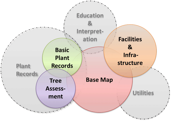
Base Map
The Base Map Module is the core of the data model and is designed for gardens that would like to use GIS to map their boundaries and natural features. This module provides the capacity to map administrative boundaries, natural boundaries, cultural features, topography, hydrology, geology, and soils. It includes a complex set of topology rules that control the quality of your data and make it easy to find and correct errors.
Basic Plant Collections
The Basic Plant Collections Module is designed for gardens that are just starting out mapping their living plant collections and do not have an existing plant records system, but can also be used by more established curatorial teams to create a GIS that links with their plant records system. This module provides the capacity to map individual plants, groups or masses, and to store the complex map labels associated with them. It is designed to only store the information used in the production of collection maps, and attempts to minimize the duplication of information that may be stored in a comprehensive plant records system.
Tree Assessment
The Tree Assessment Module is designed for gardens who would like to perform a comprehensive health, hazard, and benefit assessment of the trees in their collection. This module contains all of the functionality of the Basic Plant Collections Module, but also allows an arborist to collect information related to tree health which can be used with the included geoprocessing models to calculate condition and hazard ratings based on the Neighbourwoods and ISA standards. Functionality is also included for collecting the data necessary to perform an ecosystem services evaluation based on the USFS iTree-Eco model. There are even features included for tracking soil samples and water quality samples that may impact tree health.
Facilities & Infrastructure
The Facilities & Infrastructure Module is designed for gardens that would like to manage their facilities and other related assets with GIS. This module provides the capacity to map structures, paved surfaces, transportation, visitor amenities, and more. It is designed to work with existing software such as ZIMS for animal collection management and MicroPAVER for pavement management.